!! Page now refreshes every 5 minutes !! Close your browser if not viewing! Secondary Web Cam Page (most dead)
Silverton Web CamsPagosa Springs Web Cams
|
Main Ave between 6th and 7th street looking towards the Strater hotel

Silverton CDOT Webcams:
Looking North up 550.
Looking South towards Silverton.
Road Conditions:
National Weather Service - For Durango, Colorato
http://weather.noaa.gov/radar/mosaic.loop/DS.p19r0/ar.us.conus.shtml (NOAA National Loop)
http://www.crh.noaa.gov/ifps/MapClick.php?MapType=3&site=GJT&CiTemplate=1&map.x=194&map.y=238 (NOAA Forcast)
http://sd.znet.com/~aringler/forecast.htm (Combined Weather Channel Forecast maps)
http://sd.znet.com/~aringler/jet.htm (Combined Weather Channel Jet Stream Forecast maps)
http://geosurvey.state.co.us/avalanche/
(Avalanche Prediction map for
http://www.cotrip.org/roadConditions.htm (Colorado Road Conditions)
NMRoads.com (New Mexico Road Conditions(Pagosa Webcams) (Metar Weather Data)
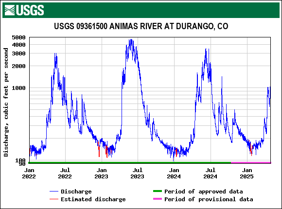
(Snowtel Data source - Where the graph below is derived. Can pick river and snow data locations)


Water vapor satellite image
(click HERE
for loop)

Visible Satellite image (click HERE
for

CX-9 Above - N6051L Below


CO-160:0.2 mi W of USFS 143


PAGOSA SPRINGS (RWIS)
WOLF CREEK PASS (RWIS)
Wolf Creek Pass Information Sign: